
Our friends at Dirty Freehub had a proposed gravel route that needed vetting so we checked it out. We broke it into two separate loops and rode the first loop the other day and posted about it here. The second half of the proposed route is where we ran into difficulty. We ran into closed, and gated roads twice and had to turn around. Our ride was still beautiful, though mostly road the way we did it. Our ride was 37.5 miles with 2768′ of climbing.
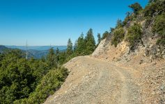
The starting point of historic Union, situated on Catherine Creek at the southern edge of the Grande Ronde Valley, is beautiful. Union, the City of Victorian Heritage, has maintained a lot of its late nineteenth century charm. The name of the town was a demonstration of loyalty and support to the Union during the Civil War. We pedaled up along Catherine Creek past Catherine Creek State Park which has a small campground and large day use area. Another couple miles later we started to climb. Around mile 13 we turned right onto gravel forest road 2034 and kept climbing. This climb is much gentler than the first part of the loop from the other day and it’s mostly shaded. We didn’t come across anyone else up here and it’s very quiet.
Following the proposed route, we turned off onto a dirt road and very quickly came to a stop. A cable stretched across the road with no trespassing sings. Curses! We turned around and backtracked down to another promising looking gravel road we passed earlier but this too had a locked gate across it with no trespassing signs about half a mile down. Oh well, not everything works. There are a maze of logging roads out here to explore and eventually something will work out.


Leave a Reply