
Rift Valley Singletrack
After our big ride the other day we decided to take it easy on our ride today. Plus it started to spit rain so we cut our ride short. Our loop was 12 miles with 933’ of climbing. In sections, the trail is a bed of clay type dirt and gets pretty gloppy under wet conditions so we didn’t want to take that chance.
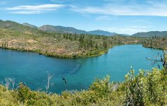
The Rio Grande Rift Valley here in Taos is purportedly one of a few areas in the world where you can see a rift valley. Most river valleys are eroded by the rivers that flow within them. However, the Rio Grande did not erode the broad flat valley; it took advantage of the presence of low areas along which to flow. The Rio Grande Rift is a place within the North American plate where the Earth’s crust has thinned and dropped downward. Both sides of the rift pull apart with the lower crust and upper mantle stretching like taffy. It’s a dramatic backdrop for three days of riding we did in the area.
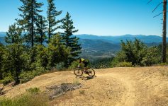
The Taos Valley Overlook Trails or Rift Valley Trails are just off the highway in a wedge of land stretching out to the cliffs of the gorge. There isn’t a huge loop here but enough for a quick ride, or you could ride multiple laps. There are no sustained climbs or gnarly technical sections, just tight twisty singletrack with enormous views. It’s a quick ride and while we intended to ride more, we let the threat of rain stop us.
Rio Grande Gorge Ride
We haven’t ridden our gravel bikes in a long time! Today we swapped out our mountain bikes and hit some mixed surfaces for a great out and back ride down in the Rio Grande Gorge. It was 26 miles with 1200’ of climbing…practically a day off! I love my Salsa gravel bike, it is so fast that it feels like I’m on E-bike.
We started by the tiny community of Pilar on a nice meandering paved road along the Rio Grande. There is very little traffic and the speed limit is only 25 which we can almost keep up with…if we weren’t stopping to take pictures all the time!
Once we reached Junction Bridge, we climbed up to the top of the gorge on the little used dirt road that switchbacks up. We rode this as part of our Slide Trail and Petaca Point day last week but we were on mountain bikes. At the top we rode out and back on the West Rim Trail along the gorge heading back towards Arroyo Hondo. Again, this is all very easy terrain. This ride is about the beauty and uniqueness of the experience. More bighorn sheep graced our presence and we stopped to take their picture.
This was a really nice, peaceful and quiet day. We saw one other cyclist all day. As an aside, there are quite a few little campgrounds right on this section of river that are only $5 a night. They are all closed because of the virus, but in another time I imagine they would be popular. The river is RIGHT THERE!
Hi there! I’m traveling to Taos for the month of April the gravel section in this post looks rad but I can’t seem to locate the road on the map. Is there any way you might be able to pass that along? Thanks!